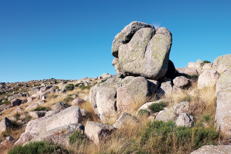
Montselgues blockfield

MONTSELGUES
Montselgues blockfield
Medium
4h
10,6km
+241m
-240m
Loop
Yellow markup
GR
GRP
Embed this item to access it offline
Ideal for a family outing, the loop of the Montselgues blockfield, 8 km, cannot fail to impress you. The road uphill from the piedmont to Montselgues is in itself a wonderful experience, with the majestic landscapes of the Corniche des Cévennes (on which the road has been built). In Montselgues, you will be captivated by the peculiar atmosphere of this place that seems so remote. The path takes you to the heart of a landscape dominated by the mineral element: granite. Here, natural erosion reduced the rock to a multitude of stones of all sizes, shaping a landscape of natural sculptures... When they are piled up, they are called blockfield, chaos in French, a word that perfectly conveys the feeling evoked by those heaps that sometimes seem to defy gravity. The blockfields geology created a type of house unique in the Ardèche. In short, you will find in Montselgues an evocation of granitic Brittany suffused with a whiff of legend.
Description
- First, take the road that goes north out of the village, in the direction of Teste Rouge and Pradon.
- After about 100 m, turn right on a stony path leading to la Borie, 2 km away. You will first have to confront a difference in height of 90 m uphill, then the equivalent douwnhill, and you will see how unlike those two slopes are. On the first part, you will not find any blockfields but, on the contrary, a quiet landscape, very green, with gentle shapes and a moderatly steep gradient. Stone buildings bear witness to old developments : the rocks and walls along the way, the cross, the small bridge, the calade (cobblestone path), the paving on the path made out of grey, pink, yellow granite stones...
- Once you reach the road leading to la Borie, follow it uphill on your left for about 100 m, then pass the tight bend of the road, leaving the shed on your left.
- After 20 m, the path leaves the road and passes between the two houses on the right to climb among rocks up to Petit Paris, perched on the top.
- Go through the hamlet. Just out of Petit Paris, a bench carved out of stone invites you to sit down for a while. The walk continues on a path lined with rocks. After 1 km, you will see on your right one of the most beautiful granite blockfields in the area. A natural treasure less unusual in Brittany or the Auvergne, not to mention the numerous places around the world where the old basement rises to outcrop, on every continent.
- 500 m after the blockfield, you will go through the Cayres hamlet, a toponym that could mean either angle or remote place. You can pick the meaning you like.
- Carry on after the farm and take the road (yellow markings) on your left, follow it to the end of the downhill gradient, then take the track suitable for vehicles in front of you towards the ridge.
- The way back to the village will take you on the ridge of one of the plateau de Montselgues' corrugations, first called Pierre plantée, then Serre de Teste Rouge. The word serre means, depending on the place, an elongate mountain or a high point with gentle or rounded slopes.
- Once on the road, at the pass, take the tarmacked road that goes directly down to Montselgues, your starting point.
- Departure : On the road to Teste Rouge, then 50 m after the La Fage inn, turn right.
- Arrival : Parking de la salle des fêtes, Montselgues
- Towns crossed : MONTSELGUES
Forecast
Altimetric profile
Recommandations
Itinéraire de montagne à plus de 1000 m d’altitude, météo changeante. Prévoyez de l’eau, des chaussures adaptées à la marche, un coupe-vent, une tenue adaptée à la météo du jour. – Fermez les clôtures et barrières, même si vous ne voyez pas de bétail. – Chiens tenus en laisse. – Feu interdit.
Information desks
Office de tourisme des Cévennes d'Ardèche
Joyeuse/Les Vans
Transport
Limitons les déplacements en voiture, pensons aux transports en commun et au covoiturage. Tous les transports en commun sur transports-region-auvergne-rhone-alpes
Access and parking
Montselgues
Parking :
Parking de la salle des fêtes, Montselgues
